Of
all the many things that Henry David Thoreau once said aloud or wrote down,
there is one particular quote that has tormented and spooked the generations of
nature-writers and tree-hunters to come.
In Wildness is
the preservation of the world.
He
wrote that down about halfway through his lecture, Walking.
A
few paragraphs later, he wrote: I believe
in the forest, and in the meadow, and in the night in which the corn grows…Give
me a Wildness whose glance no civilization can endure.
Just
the other day, I was driving towards Center City and I passed by the same idea,
shouting to be heard.

It’s
an opinion that is and always will be a little outlawed.
Many
people are quick to note that Thoreau uses the word wildness and not the common term of the day, wilderness. He did it
deliberately. He was being
stubborn. He was stubborn, and
deliberate, for a lot of his life.
To
Thoreau, wilderness was something
invented by the Law, governed by a Mayor, a piece of land under ownership of
the State. The modern day wilderness is
paved and permitted, gated up for seasons, open only from dawn to dusk, guarded
by a Police.

The
boundaries of a wilderness are always in dispute. Its title is something that can be repealed,
rescinded or revoked. Its map is
something that can be taken away, written over.
But
wildness?
No
chance, no dice.
You
cannot stop the wilds.
Even
here in Philly?

Yes,
even here in the big city.
To
prove it though, I’ll need to discover and explore Philadelphia for the
palimpsest that it really is.
What’s
a palimpsest? It’s a manuscript or a document that has been
scraped clean and erased, then replaced with something more modern but that
still bears the traces of the earlier work.
Sometimes
in order to read the earlier work, historians and archaeologists need to flash
the palimpsest through ultra-violet light, the only way to see what was written
before.
I
don’t need that kind of technology.
I
just need the right kind of map.
I’ll
use this map.

It
was made by the City Planning Commission in 1934. Using historical texts and field guides, colonial
journals and living memories, it’s meant to depict this city as first seen by the White Men...

…when
Philadelphia was known as Coaquannock, the Grove
of Tall Pines.
“OF ALL THE MANY
PLACES I’VE SEEN OF THE WORLD…”
According
to the map, Coaquannock was one of four circular villages of the Turtle Clan, all
located within the watershed between the Schuylkill and the Delaware River.

There’s
no record, no description of the pine grove that it was named for.
But,
by the coming of the white men, the Lenni-Lenape had already been living here
for thousands of years. It’s quite
possible that they named the town in memorial of the pines, a dedication to the
grove that was standing in some distant bygone era, same as we do now.
What
was it like?

The soil is good
– air serene and sweet from the cedar, pine and sassafras, wrote William
Penn in one of his famous letters back home, with a wild myrtle of great fragrance.
Tracing
the bends of the Schuylkill River…


…I
can place Coaquannock in roughly the same spot as Fairmount Park and the Laurel
Hill Cemetery.
Last
Memorial Day, I went tramping through the rainy summits of Laurel Hill…

…but
I wasn’t able to find any sign of the town or people of Coaquannock…

….even
though it was all there, bumping and jumping just like any other city, only
three hundred and fifty years ago.
Here
in Philly, there are trees older than that.

If
there’s any preservation of Coaquannock left in Fairmount Park, then I missed that
too although, last autumn on an afternoon adventure to catch some color…

…I
did find an Indian statue.
The
town on the west side of the Schuylkill?
That was Arronemik.
Not
much information about that one either.
When it comes to these old towns, my best and sometimes my only help is this map. I
look in it for details. I try to read
the map like a book, looking for little jumps in the narrative.
I
notice that these towns, surrounded by woods, are still depicted with
agriculture.

The fruits that
I find in the woods,
wrote William Penn, are the white and
black mulberry, chestnut, walnut, plums, strawberries, cranberries,
whortleberries, and grapes of divers sorts…

…the artificial
produce of the country is wheat, barley, oats, rye, peas, beans, squashes,
pumpkins, water-melons, musk-melons, and all herbs and roots.
Just
south of Coaquannock and Arronemik, right before the good and fertile country gets
swamped in mud and marsh, there was the Turtle Clan town of Passyunk…

…and,
to the east of Passyunk, the land known as Wickawacoing, which a combination of
two words, creek head and pine.
The
Wickawacoing name is still kicking around but it’s been changed to Wiccaco…

…or,
sometimes just around the corner, we spell it Wecaccoe.

The
original name for Passyunk was Pachsegink, meaning in the valley. Even back
then, it was known for its trail…

…an
efficient and popular path that the modern paved Passyunk Avenue still follows…

…although,
in order to see the original Indian trail, you have to develop the knack
for checking out the backs of signs…

…or
the bottoms of your feet.


This
was the trail from the southern village of the Turtle Clan, through the open
meadows and farm fields of Wickawacoing…

…straight
into the bustle and hustle of center city Coaquannock.
That
part on the map that says The Dock?
That
was one of our first names given to this watershed. That’s
where they landed…

…the
recipients of all those William Penn letters, convinced at last to just see it
for themselves.
Of all the many
places I have seen in the world, he wrote, I remember not one better seated; so it seems to me to have been
appointed for a town…

…whether we
regard the rivers, or the conveniency of the coves, docks, springs, the
loftiness and soundness of the land and the air.
The
first order of business for the Quaker settlers?
De-forest
the city.
According
to John Watson’s “Annals of Philadelphia in Olden Time,” Even solitary trees of sublime grandeur were not
spared…so general was the havoc in process of time, that none remained of all
the crowded forest, save a cluster of black walnut trees, which, of late years
stood opposite the State House on Chestnut Street.
Walnuts
opposite Chestnut Street? That’s
something that’s still preserved…

…from
a certain point of view.
The
original Quaker settlement was simply called The Hill, later re-named to
Society Hill. Some aspects of this first
colony are still present…

…in
the general lay-abouts of the town grid and the street names…

…although
even names don’t last forever.
All
this clear-cutting and map-making was worrisome for the Lenni-Lenape…

…and
so, in 1683, a great council was summoned between the sachem-chief of the
Turtle Clan and the big brother of the Quaker tribe…

…to
take place under the great elm that stood near the wigwams of Shakamaxon.
There
is a painting hanging in the Art Museum that captures this scene.

In
the spirit of amity and friendship, the great chief Tamanend accepted the
promise of William Penn, also the money for the purchases of The Hill and The
Dock. Then, he made his own promise...

…we will live in love with William Penn and
his children as long as the creeks and rivers run and while the sun, moon and
stars endure.
To
preserve this great promise, we built a Tamanend statue at the corner of Front
and Market Streets.

For
his own amity, William Penn also received a statue.

The
placement of his outstretched hand is the butt of many jokes here in Philly…

…which
is a shame. That’s the most important
part of the statue, a good spot in the palimpsest to see a tiny bit of the
whole picture.
His
friendly gesture is mirrored in the statue of Tamanend...

…the
handshake across Old City.
But
actually he’s pointing, pointing in the direction of his sister-statue in Penn
Treaty Park…

…the
site of that once great Treaty Elm, under whose bower of shade so many promises
were made.

“AS LONG AS THE
CREEKS AND RIVERS RUN…”
Just
the other day, I found myself meandering on another constitutional walk and I
paused to rest on the railings of the bridge on Old Sassafras Street.
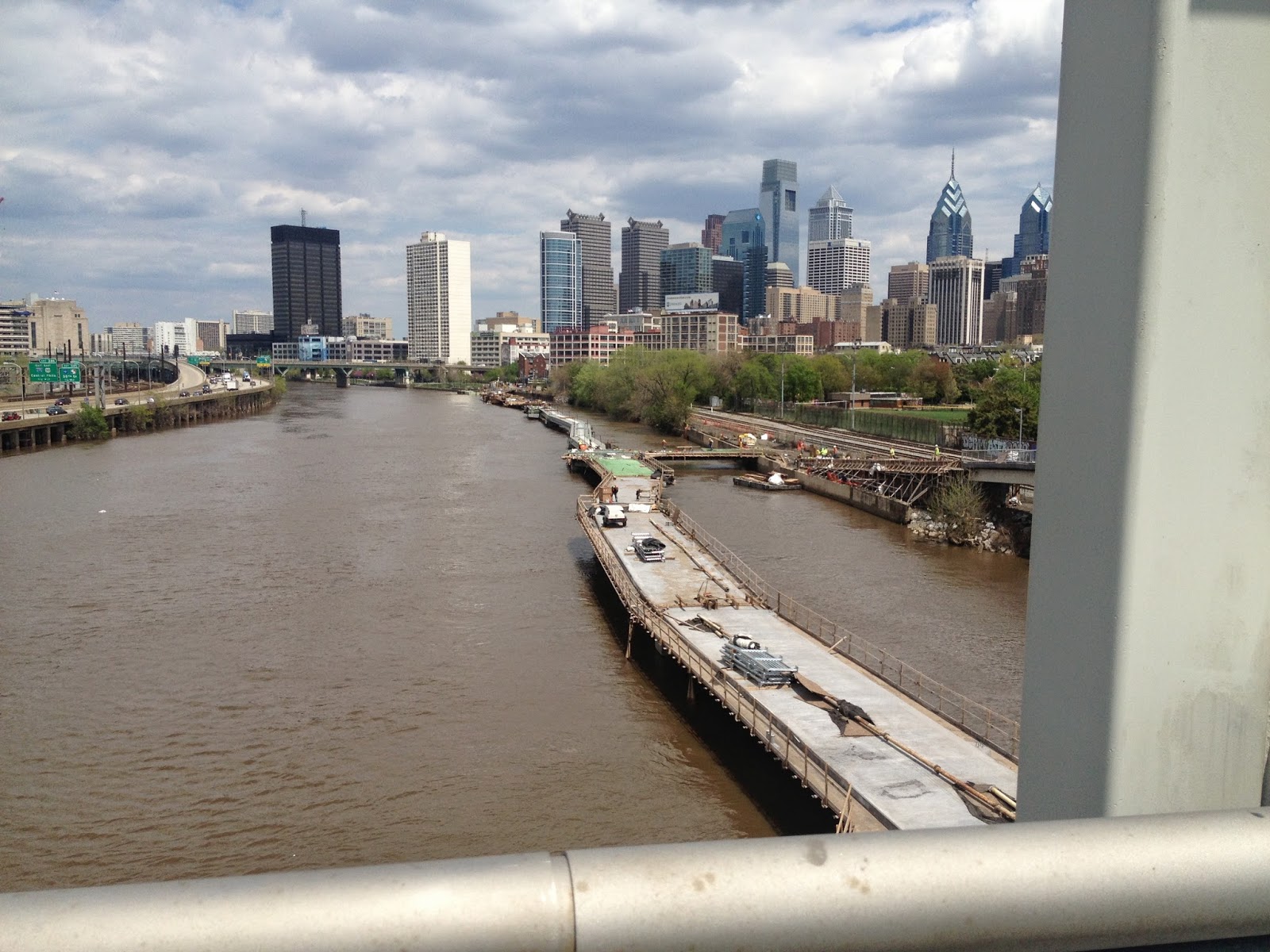
I
watched the construction crew building the latest addition to the Schuylkill
River Trail.
This
will be a two-thousand foot boardwalk from Locust Street to the south side of
the South Street Bridge…

…running
parallel to the eastern shore.
It’s
about time we return to our waters.
The preservation of our waters is part of Tamanend’s friendly promise…

…we will live in love with William Penn and
his children as long as the creeks and rivers run.
He was trying to say forever. He based his promise on the foundation that such things like creeks and rivers are permanent, always on the map.
We figured out the loophole to that promise.
We figured out the loophole to that promise.
We’re
running the creeks dry.
Most
of them have been turned into sewers.


Exploring
and discovering the Philadelphia woods, no matter how high I climbed or how
deep I dove, I was never far from the kingdom of sewerage…

…never
could escape the subterranean network that keeps the toilets flushing or the
showers pumping…

…or
the coffee machines churning.
Most
of the little creeks are gone underground and their courses are all but
forgotten, little waterways like Mill Creek, Rock Run and even Dock Creek, gone
away, dried up, raised high and buried over.
Even
creeks with great history have been submerged, places like Moyamokin, Where We Enter the House...

…and
Chinkhansin, Where We Were Robbed.
All
the way south on the map, I can still find Tennakonk…

…although
I know it as the John Heinz National Wildlife Refuge at Tinicum.

I’ve
wandered those trails through all manners of seasons and moons. Even now, the map stays true. Tennakonk still holds the promise of birds.

Just
north of Tennakonk, there’s Mud Island.

I
was there too, a couple winters ago…

…to
march along the high ramparts of Fort Mifflin…

…and
to walk along the mucky banks of the Schuylkill River delta.

Over
the last two years, I’ve tried to hit all the remaining streambeds and creekruns.
I’ve
followed Cobbs Creek, the southwestern boundary of the city, from where it
flows into Philadelphia under City Avenue…

…all
the way to the weird outpost of Eastwick…

…land
of wild turkeys…

…and
dusty ponies.

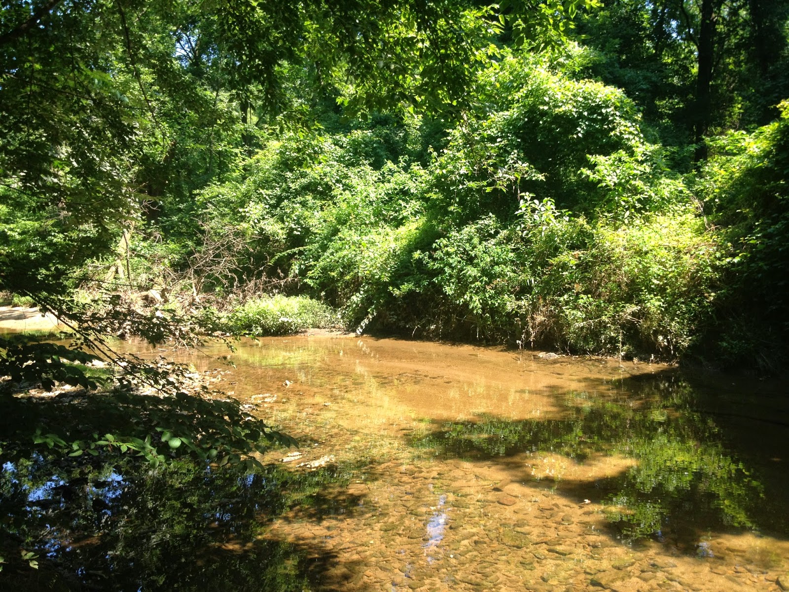
I
spent a long summer day at a rocky bend of the Catfish Creek…

…and,
during winter, I went back again to make war with the polar vortex.

The
northeast corner, the northernmost boundary of Philadelphia, is also a creek…

…the
Poquessing, The Place of Mice, an
appropriate perch for an owl.
I
was there last summer, during the Strong Sun Moon, in the middle of an infernal
heat wave…
…hunting
down the native sunflower, stumbling blindly into the grove of a modern day sun
god.

I’ve
been up and down the Pemickpacka watershed, looking for spring, chasing the
pawpaw…

…The Slow Flowing Bear-Fat creek we now
call the Pennypack.
Even this mighty
river has been diverted underground in parts but, even within its driest woods, during certain slants of light…

…I
could find it, bubbling back to the surface.
What
about the Taoconink, the Tacony?
That
flows into the city through the Cheltenham and Lawncrest neighborhoods and,
right before turning towards the shore, it becomes the Quessinamomink…

…which
some translate as Eel-skin River.
I
thought at first that this creek would spill into the Delaware at the anchorage
of the Tacony-Palmyra Bridge but it’s actually more south at the site of the
Betsy Ross.

I
tried to find the place where it flowed into the Delaware but I couldn’t get
any closer than this…

…unless
I applied for a job with Veolia Energy, whose northeastern headquarters lay
claim to this part of the creek.

Just
north on the map, between the Betsy Ross Bridge and the Pemickpacka, there
is another creek called the Wischanemuck, the place Where We Were Frightened…

…a
name whose meaning is lost to the past.
It originally ran from the north just below a wide swing of the
Pemickpacka but now its course has been sunken and corrected…

…flowing
back to the surface in the neighborhood of Bridesburg.
We
now call it the Wissimoning and I was able to catch it on the overpass where
Bridge Street intersects with Almond Avenue.

I
couldn’t get to its northern banks. It
was locked up by Dow Chemicals.

On
the other side of Bridge Street, I snuck into the parking lot of the Ross
Funeral Home and was able to catch its flow…

…traffic
zooming by me, high water standing still, Honeywell factory in the background
working hard.
There
was also once the Wingehacking, known to be A
Favorite Spot for Planting…

…but
it’s been sunk too.
The
only place left to find it is here…

…at
the Awbury Arboretum in the East Germantown neighborhood.
The Wingohocking surfaces, quietly and
humbly, just underneath West Washington Lane.

It
runs through the park…

…gathers
for a little bit in a mossy pond defended by a massive river birch…

…and
then continues babbling and bending down its brief course.

To
the east, there is a steep valley and
a high, delightful trail of sentinel trees.

Right
before it ends, the Wingohocking pools into a reedy puddle, guarded by two
willows…

…which
is just about perfect, and then it flops over the rustic dam and back into the earth…

…never
to be seen again and that’s that. It’s
not even on our current map.

It’s
a sewer now and I have no problem with sewers.

I
live above a sewer myself. It was once
called Mill Creek. I know the course it
once ran. It used to pool from the mills
into a small pond, famous for its mud, on the Chester side of Clark Park.
I
can identify a few of the trees and plants that once towered over its bends and
bows.
These
sewers and I? We are separated by a young
but tenacious layer of the palimpsest.

But
between us, between my sewer and me, there is a history that digs deep…

…and,
as long as it runs, a promise worth keeping.
“THAT’S WHY
NOBODY KNOWS THEY’RE HERE…”
The
entire northeast and most of the western range of the map is dominated by the
wilds.

I
can zoom in on the trees and try to see some distinct characteristics…

…but
I’d only be guessing.
Many
accounts speak only of their fruit.
I
can’t recognize any landmarks except for the obvious ones…

…like
the cliffs of Manayunk, Where We Go To
Drink.
Right
where the Wissahickon Catfish Creek makes its final drop to the Schuylkill, on
the eastern side of the falls, there was once the outpost of Nittabakonck…

…The Place of the Warrior.
There
is almost no information about it. I can
place it in the neighborhood of East Falls, that’s it.
It’s
not the only thing that’s disappeared from this map.

No
more black bears. The bear sightings
happen on the other side of the river in Jersey.
Close
to The Dock, in what later became Aramingo, there was a small creek called
Tumanaraming, the Wolf-Walk.

No
more wolves. Closest thing was a
wolf-dog…

…who
haunted the edges of the Pennypack woods back in 2012, creating a brief bit of
hysteria.
The
real concern right now aren’t wolves.
It’s coyotes.

In
2004, the Inquirer ran a story entitled, “Coyotes Have Come to a Town Near
You.”
According
to a state wildlife officer, They are in
the backyard, and people don’t know it…

…but people have
to understand, these animals don’t hide behind rocks waiting for little Johnny
to come out on the playground. They
don’t eat people.
Three
hundred and fifty years in this watershed and people still need to be taught
the ways of these wilds. We’ve been
given a very generous grading curve.
In
the same article, a local trapper confirms that they travel the railroad tracks.
It’s like a superhighway to them, and that’s how they get around cities
and towns…

…see, that’s why
nobody knows they’re here.
There’s still plenty of deer though.
Too many deer, they say.

Back in 2000, the National Wildlife
Department spent some nights watching the Philly woods, hovering in
helicopters equipped with infra-red scanning.
They counted 635 deer, roughly 120 deer per square mile.
They recommend that, in a city like
Philadelphia, the average should be closer to nine.
Since that study, during the last phases of the Long Snow Moon, the Fairmount Park
Commission closes the parks at night but they will admit a deputized troop of
dues-paying deer hunters to help thin the population.

I see deer all the time in the woods
but I’m never quick enough to catch a photo.
If I’m lucky, I’ll find a frog.

In the spring, I can find tadpoles…

…and, during the best part of spring,
I can find them both at the same time.

If I’m especially lucky, I’ll find a
snake.

But most of the time, I find only
the remains of animals.

I could zoom in on some of these
remains…

…try to find some sort of shape or
pattern that I can recognize…

…but I’d only be guessing.
And the Lenape? What happened to them?
By the time of William Penn’s
landing, their population had dwindled down from 20,000 to 4,000, almost all of
them huddled up here by the Delaware.
Their population had thinned so much that they had to combine clans.

They had been ravaged by smallpox
and measles. They were in terrible debt,
both in wealth and lives, from years and years of steady war with
the Iroquois from New York.
By the middle of the 1700s, most of
the Lenape moved to the other side of the Poconos, the beginning of a great
wandering.

Most of them ended up in Oklahoma.
There are very few left that can still
speak the language.
There are programs and classes and
initiatives trying to keep the language alive but it’s got some hard grammar.
Verbs are suffixes, except when the
verb is a place. Gender is prefix. Most of the time, it’s just putting beginnings
and endings in front or in back of the word, so an action-packed sentence is
actually just one long yodel.
It’s almost impossible to learn from
a book because their thoughts, directions and stories often incorporated hand
gestures, pantomime, smiles.

Nouns are either animate or
inanimate and sometimes it doesn’t make sense, like plants that grow their
fruit above ground are inanimate while root plants are animate.
Maybe that’s just the way a farmer
thinks.

It's considered a dead language but I got a problem with that.
What about me? Why not us?
I use their language all the time. I drop their words, their place-names, into almost every conversation. So do my friends.
We are the keepers of their language.
What about me? Why not us?
I use their language all the time. I drop their words, their place-names, into almost every conversation. So do my friends.
We are the keepers of their language.
It’s almost as if the city hasn’t
realized yet that they’re gone.
They persist.
I see it all the time when I'm out there tree-hunting. The young honey locust...

...they're still arming themselves against the giant sloth and the dire wolf. In April, the ginkgo leafs out...

…a tree that was lost for millions
of years, completely off the map but for one small mountain grove in China. In July, the lost camellia called the
franklinia will be flowering.

This usually happens right at the
beginning of heirloom tomato season.

Just down the road, the osage orange stands
alone but steadfast, stubbornly and persistently going through the seasons.

Every year, it keeps plowing onward from flower to fruit.
Every year, it keeps plowing onward from flower to fruit.

It's hard work but who else is going to feed all those wooly mammoths?

TO BE CONTINUED...stay tuned for the thrilling conclusion to The Philadelphia Palimpsest story (the working title is "I'm Off the Map, Now Get Off My Back") and the very last episode of the Philly Trees blog.
This is it, one final adventure left.
Rumors are already spreading about the grand finale. We are able to confirm that there will be one last walk through the woods but which woods? What is Jon Spruce hunting? Will the hawthorn bloom? Will the sycamore leaf out? Who wins? The city or the trees?
We were able to track down Jon Spruce at his telephone to ask these burning questions. Will he give away any spoilers about the end of Philly Trees?

"Sure I'll tell you the ending. Why not? It's already been told hundreds of times before.

"All the plants and animals of Turtle Island get together in a big circle and save the world."

Okay.
So stay tuned for that, the final Philly Trees adventure, coming soon to an internet near you!
Absolutely Brilliant!!! Research is incredible. Writing is amazing
ReplyDeletewonderful..!!!marvelous pictures and I like all
ReplyDeleteThank you for this great post, I really enjoyed it. Would you know where I could acquire a copy of the 1934 map?
ReplyDeleteThis is an amazing piece of research and a fascinating story woven together with the web of life. Great work and thank you!
ReplyDeletenice Post ! Student needs a platform to support them in writing, it is important because they submit the assignment in school and colleges , lots of companies providing the assignment writing service to student so they support and give them professional quality writing.
ReplyDeleteDissertation writing services
I have an original 1938 map that I got from a friend. I love it even more now that you have used it as a modern day reference. Thank for all your amazing work and information.
ReplyDeleteA blog is one of your most important marketing tools. Customers love blogs because they're generally full of great free information. Here are 5 tips for writing a good blog.
ReplyDeletecpm book answers call +1-845-546487
My friend mentioned to me your blog, so I thought I’d read it for myself. Very interesting insights, will be back for more!
ReplyDeletelatest sarkari results
Wanishi wemi
ReplyDeleteThis has been a really fun read. I visit the Landsdowne Creek by the Horticultural Center several times a week. Currently there is a revitalization project happening there. They are trying to remove all of the invasives and put up a deer fence to preserve the tiny native saplings that they planted. I've been told that there is a stone there called the turtle's back and there could have been a burial place that 76 now crosses over. Carved into a bench reads, "visit the cave between 76 and mlk drive." I still haven't found the cave and it's been something that keeps me up at night. It may be worth a visit.
ReplyDeleteI read this article this because this information will be best for travelers my sister share with me. Coming back from bus tours from new york. I will again read this article and share with others.
ReplyDelete